OLD FORTS OF WYOMING
It has been a tradition for the past few years to go back to Shirley's home state of Wyoming and visit places where she has been and wants me to see; or, go to places we both want to explore. We do this with Shirley's brother Terry and his wife Donna.
Terry and I have been reading about the old west and the part Wyoming played in the settling of the west. For the past two years, we have been talking about visiting the old forts (Shirley said we didn't have time to visit all the old farts). Three of the restored forts are located rather close together. This made it fairly easy to select Fort Caspar, Fort Fetterman, and Fort Laramie as the forts to visit on this trip.
As you can see from the map below, these three forts are fairly close together. Don't let this fool you as it took two to three hours to tour Fort Casper. Fort Fetterman has not been restored to the extent of the other two, but took a little over an hour to tour using a golf cart. We spent close to four hours touring Fort Laramie because it has been more fully restored and covers much more area than the other two.

The map above shows the location of the Forts along the Oregon, Mormon, California, Pony Express Trail (These trails were all one trail until they split to go to the differing locations: Oregon, Salt Lake Valley, and the Sacramento area. All Forts were built along the North Platte River.

Oregon Trail Marker at Fort Caspar Museum

Pony Express Marker at Fort Caspar Museum

Countryside near Fort Caspar

Countryside near Fort Caspar is similar to that where Fort Fetterman and Fort Laramie are located

FORT CASPAR

Fort Caspar as seen from the Museum (buildings are recreations of the original fort)

Military forts are usually named for officers killed in battle using the last name. As you can see from the sign above, Fort Caspar was originally call Platte Bridge Station as the Fort was also established to protect the bridge across the North Platte River. The officer's last name was not used in this case, as his father name had been used to name Fort Collins in Colorado.

Map of Fort Caspar

Sutler Store
The Sutler was franchised by the regiment, moving with the troops from one fort to another and supplying soldiers with a variety of goods including clothing, tobacco, food and liquor.


Inside Sutler Store

Inside Sutler Store

Blacksmith Shop with Corral at left
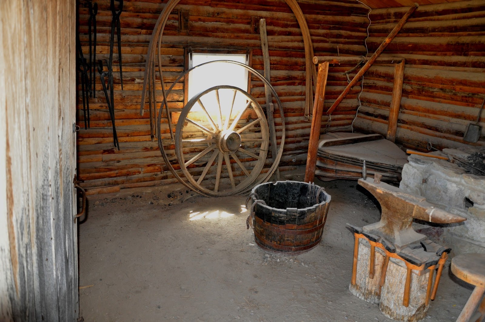
Inside Blacksmith Shop (left side)

Inside Blacksmith Shop (Forge in center of shop)


Inside Blacksmith Shop (right side)

Parade Ground

Commissary

Inside Commissary

Inside Commissary

Fort Garden

This well supplied water for the Fort

Kitchen (left), Barracks (center) Trading Post/Telegraph Office (right)


 Fireplace in Kitchen

Inside Barracks

Inside Barracks

Inside Barracks

Terry, Donna, and Shirley at Trading Post and Telegraph Office

The rail and Plexiglas with my shadow are placed just inside the rooms to allow one to step inside and view the room without allowing access to the room. These are placed in every area open to visitors.


Officers Quarters were much different than the Enlisted men

Officers Saddle - much better than a regular Calvary saddle
(See Fort Fedderman for picture of Calvary saddle)

Officer's Desk and Closet

Stables attached to the Officer's Quarters (Officers horses)

View of Fort Caspar from the bank of the North Platte Fiver near the site of the Platte Bridge

Mormon Ferry with Wagon

Old Platte Bridge

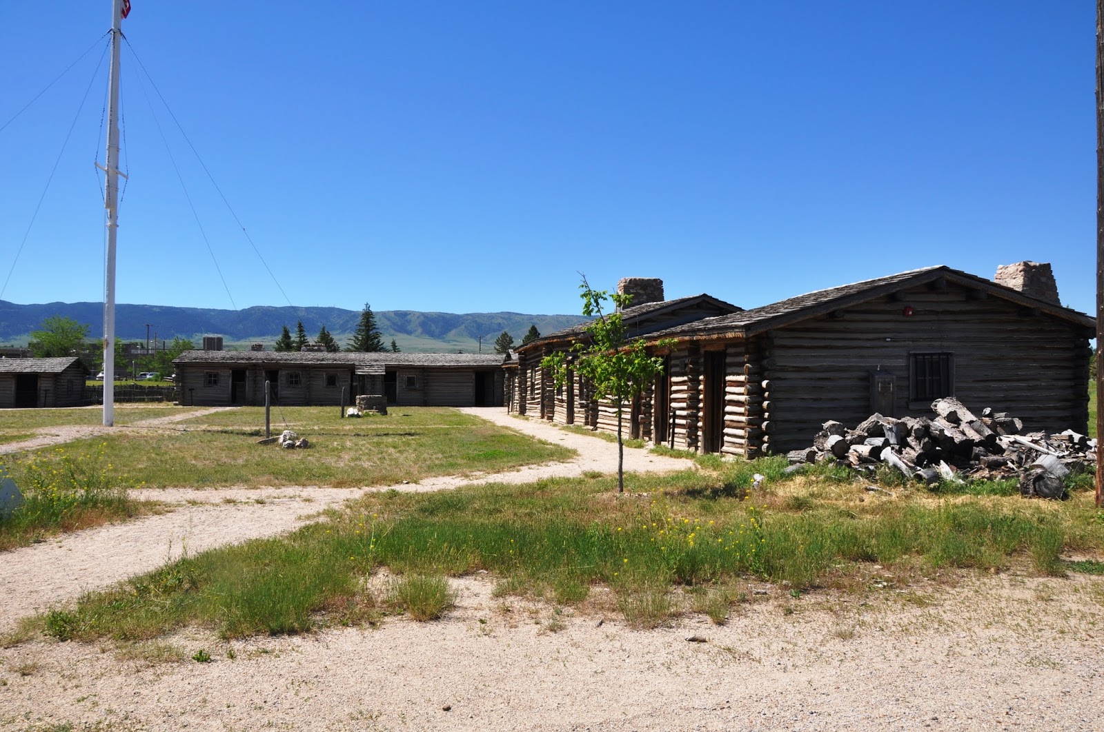
The only buildings remaining at Fort Fetterman are the Officer's Quarters (log building on right) and the Ordinance Building (white building on left). Cemetery is fenced area to left of Ordinance Building below power lines

Map of Fort Fetterman shows where buildings were located

Shirley and Donna resting outside the Officer's Quarters

Room inside Officer's Quarters


The term "Hog Ranch" was used to describe off post facilities which provided wine, women and song to the lonely soldiers of a military post. Fetterman's Hog Ranch was off limits to the soldiers and was located on the opposite side of the North Platte River.


Fort Laramie covers 536 acres so this photo shows only the monument at the entrance from the parking lot.


Parade Ground
Building on left in background is the Commissary. Next is the Kitchen with the Barracks (large building in the center) next and the Telegraph Office on the far right.
Normally there were about 20 soldiers and accompanying officers station at Fort Caspar. Their main duty was to protect the Iron Bridge crossing the North Platte River which was a major traveled road. At the height of the Indian Wars there were as many as 120 men stationed here. The enlisted stayed in tents similar to those in the extreme right.

The Corrissary was built by the Army in 1862 and housed the garrison;s food stuffs and supplies. A typical army meal on the frontier included hardtack, salt port, rice, coffee, beans and broun sugar. If the soldier wanted something else, he could purchase food items from the post sutler and grow vegetables in small gardens.

Inside Commissary


Fort Garden
Friendly Indians were allowed to camp outside the Fort. They were allowed inside only during certain times.


Kitchen (left), Barracks (center) Trading Post/Telegraph Office (right)


Fireplace on opposite wall in Barracks

Inside Barracks


Inside Barracks
The bunks slept two men to a bed. Soldiers from the 11th Ohio Volunteer Cavalry were stationed here beginning in 1862. The 11th Kansas Volunteer Cavalry, Third U.S. Infantry and the Sixth U.S. Infantry replaced the Ohio Volunteers in the summer of 1865.

Terry, Donna, and Shirley at Trading Post and Telegraph Office
Guinard Trading Post was built in 1859 for his family's private living quarters, store room and trading post. Guinard leased the end room to the Pacific Telegraph Company in 1861 to house the telegraph office.

Inside the Trading Post

Inside the Telegraph Office

Officer's Quarters with Stable on the right
The Officer's Quarters were originally built to house the employees and draft animals of the Overland Stage Company in 1859. It was converted by the U.S. Army into officer's quarters, keeping the stable and corral in 1862.

Officers Quarters were much different than the Enlisted men

Officers Saddle - much better than a regular Calvary saddle
(See Fort Fedderman for picture of Calvary saddle)

Officer's Desk and Closet

Stables attached to the Officer's Quarters (Officers horses)
Crossing the North Platte River was a major undertaking to those traveling on the Oregon, Mormon, and California Trails. The Mormon Ferry was used to get wagons across the River taking travelers to the Salt Lake Valley in the late 1840's


Old Platte Bridge
Louis Ginard (who also built many of the first buildings located at Fort Caspar) built a bridge across the North Platte River in 1858-1859. I am sure that he charged to use the bridge even though he had a trading post at the end of the bridge. Just my thinking. The river does not flow near the bridge today as it has changed course over the years.
FORT FETTERMAN
(1862 - 1887)
The plateau above the LaPrele Creek and the North Platte River was chosen as the location for an Army post by a Major Dye who described it as "... being neither so low as to be seriously affected by the rains or snow, nor as high and unprotected as to suffer from the winter winds," This was not to be as the winter winds and snow proved to be terrible. Fort Fetterman would become known as one of the worst places to be stationed and was considered by some to be a punishment if assigned to this fort.

The only buildings remaining at Fort Fetterman are the Officer's Quarters (log building on right) and the Ordinance Building (white building on left). Cemetery is fenced area to left of Ordinance Building below power lines

Map of Fort Fetterman shows where buildings were located

Shirley and Donna resting outside the Officer's Quarters

Room inside Officer's Quarters
There is also an visitor's center and a room for viewing a short video of the history of Fort Fetterman located inside the Officer's Quarters.

Uniform Jacket and Coats on display. Cavalry saddle on the right

Close up of the saddle


Cistern used to supply water to the Fort

North Platte River as seen from the Cistern
Water had to be hauled from the river, up the hill to the cistern. The pump referred to on the sign above was operated by four men moving levers up and down to pump the water to the cistern.

The term "Hog Ranch" was used to describe off post facilities which provided wine, women and song to the lonely soldiers of a military post. Fetterman's Hog Ranch was off limits to the soldiers and was located on the opposite side of the North Platte River.

The Hog Ranch was located somewhere along the river from the trees in the center of the picture to the highway on the left. As there were no bridge and the ranch was off limits it was said that more men from Fort Fetterman died of drowning ( going across the river to or from the Hog Ranch) or suicide than were killed in fighting Indians.

On May 11, 1882 the military abandoned Fort Fetterman. In September 1882 the public buildings were sold at public auction but the military reservation was not abandoned until 1890. Almost immediately after the army left, Fetterman City began to boom. It was to become one of Wyoming;s most notorious cowtowns and dens of inequity. Fetterman City prospered until the Fremont, Elkhorn and Missouri Valley railroad selected Douglas Wyoming as the terminus in late summer of 1886. By 1890 Fetterman City was almost completely abandoned.
SEE MY BLOG - TRAIN MUSEUM IN DOUGLAS WYOMING
FORT LARAMIE
Fort Laramie is located near the City of Fort Laramie, Wyoming which is 117 miles from Laramie, Wyoming. This Fort was one of the largest Forts and is the best restored of all the Forts we visited.
In 1815 or 1816, Jacques La Ramee and a small group of fellow trappers settled in the area where Fort Laramie would later be located. He went out alone to trap in 1819 or 1820 and was never seen again. Arapahoe Indians were accused of killing La Ramie and putting his body in a beaver dam. The river was named “Laramie” in his honor, and the name would later be given to the Laramie Mountains, the fort, and the towns of Laramie, Wyoming and Fort Laramie, Wyoming.
The following is from the National Park Service website: "Originally established as a private fur trading fort in 1834, Fort Laramie evolved into the largest and best known military post on the Northern Plains before its abandonment in 1890. This “grand old post” witnessed the entire sweeping saga of America’s western expansion and Indian resistance to encroachment on their territories."

Wikipedia says: "Fort Laramie (founded as Fort William and then known for a while as Fort John) was a significant 19th century trading post and diplomatic site located at the confluence of the Laramie River and the North Platte River in the upper Platte River Valley in the eastern part of the U.S. state of Wyoming. It was founded in the 1830s to service the overland fur trade during the middle 19th century. It sat at the bottom of the long climb leading to the best and lowest crossing point at South Pass into western descending valleys and so was a primary stopping point on the Oregon Trail. Along with Bent's Fort on the Arkansas River, the trading post and its supporting industries and businesses were the most significant economic hub of commerce in the region."

Fort Laramie covers 536 acres so this photo shows only the monument at the entrance from the parking lot.


The Commissary is now the Visitor's Center

Go to the Visitor's Center first to get a map to guide you through the Fort

One of four bakeries that served the Fort. This bakery was remodeled in 1818 and used as the Fort school. Army bakeries produced one 18 ounce loaf of bread for each man daily. There were 700 men stationed at the Fort.


Sutler's Store part of building

Inside Store

Post Office inside Store

Officer's Club part of Sutler's Store Building

Inside Officer's Club

It was hard to get good pictures with reflections in the windows

The Soldier's Bar is in the opposite end of the Officer's Club. It is the first building next to the parking lot and open to the public. Because we went to the Visitor's Center first, then started our tour of the Fort, by the time we got back to this building it was closed.


Cavalry Barracks

Calvalry Mess Hall

Cavalry Barracks Inside

Army Wagon
MORE FORT LARAMIE TO COME


Cavalry Barracks

Calvalry Mess Hall

Cavalry Barracks Inside

Army Wagon
MORE FORT LARAMIE TO COME
Comments
Post a Comment